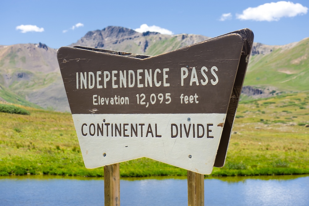
If you visit Aspen, Colorado, in the summertime, don't miss Independence Pass, one of the most scenic byways in the United States and a top tourist destination in Colorado! Independence Pass reaches an impressive elevation of 12,095 feet at the summit, and the views are unbelievable.
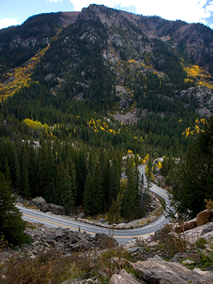
Serving as the eastern gateway to Aspen, Independence Pass has linked the Front Range to the Western Slope since the mining days, when it was a rough wagon trail. Today, the roadway is the highest paved pass in Colorado, maintained and open during the summer months (late May through mid-October).
Between Aspen and Twin Lakes, Independence Pass is bordered by White River and Pike-San Isabel National Forests and traverses the Continental Divide. With hiking trails, swimming holes, a ghost town, and the awe-inspiring views atop the summit, Independence Pass is a recreational playground that is a destination unto itself.
As we explore the points of interest along Independence Pass, we’ll start this journey on the Aspen side of Independence Pass and detail our favorite stops on the way to the summit. Read along to learn more!
P.S. For even more tips and tricks to discovering all Aspen Snowmass has to offer, please check out our blog!
Frias Properties Aspen Snowmass Blog
In this blog:
- How Can We Reach Independence Pass?
- Northstar Nature Preserve
- Devil's Punchbowl
- The Grottos
- The Braille Trail
- Independence Ghost Town
- Hiking Trails on Independence Pass
- The Continental Divide
- More Things to Do in Independence Pass
- Start your Independence Pass Adventure with Frias Properties of Aspen
How Can We Reach Independence Pass?
Independence Pass is accessible by Highway 82 in the summertime. Because of heavy snowfall, Independence Pass is closed during the winter, from approximately mid-October to late May. Always check driving conditions before heading out!
Access Notes:
- Even when the pass is open, not all vehicles may use the road. Oversized and overweight vehicles are prohibited from the pass, as are all vehicles or vehicle combinations longer than 35 feet, regardless of weight or size. This precludes the use of the pass by tractor-trailers, buses, and recreational vehicles.
- Driving the pass can be challenging. At points, the lanes are very narrow, and there are limited guard rails. Only experienced drivers are encouraged to drive the pass. Traffic can be heavy as many people pull off to the side to take photos.
Visitors to the top can park and walk up a paved path to a scenic overlook that offers views east to Mt. Elbert (the state’s highest peak) and La Plata Peak (the state’s fifth largest. Looking west, visitors can see more of Colorado’s renowned "Fourteeners," peaks over 14,000 feet, including Capitol Peak, the Maroon Bells, and Snowmass Mountain, among others. The scenic overlook offers you a view of an alpine tundra environment above treeline. Not something you can see every day!
Northstar Nature Preserve
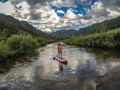
Before you reach the winter gate to Independence Pass, pull off the road to explore Northstar Nature Preserve. Walkers can head into the Preserve on the James H. Smith Interpretive Loop and see herons nesting along the river. Stand-up paddleboarders and kayakers can float the slow-moving sections of the Roaring Fork River. While out on the water, it’s common to spot beavers and many types of birds.
Devil's Punchbowl
If you enjoy the leg-numbing adrenaline when standing atop a 20-foot cliff and leaping into an icy river below, stop at the Devil's Punchbowl, just past mile marker 50 and before the Grottos Day Use area. The natural swimming hole has been carved out of rock by the rushing river over the years. There are a few different jump zones as well as viewing areas for spectators.
Use extreme caution. This is an unmaintained area with no lifeguards. Conditions are unpredictable and may change quickly.
The Grottos
With a designated parking area, The Grottos are easy to access and a great spot for a quick walk around truly stunning scenery. The Grottos themselves are caves (sometimes covered with ice) that have been formed by pooling water and ice over centuries. The Roaring Fork River continues to carve away at surrounding rock formations with cascading waterfalls that add to the picturesque setting.
The Braille Trail
Established in 1967, Aspen's Braille Trail was the first of its kind. Located at mile marker 55, it invites blind visitors to leave the roadside and explore the forest along a 0.25-mile trail. There are 23 stations with Braille and text that detail local plants, animals, and geology.
Independence Ghost Town
Just past mile marker 57, the topography widens, and the ghost town of Independence comes into view. When this silver and gold mining town was at its peak in 1882, it had an estimated population of 1,500 as well as three post offices and more than 40 businesses. Pull over to explore the remaining miners' cabins, general store, mill, and other structures.
Hiking Trails on Independence Pass
Surrounded by National Forest land, Independence Pass serves as the gateway to some of Aspen's best hiking. For a full-day adventure, hike the iconic Lost Man Loop, which passes by two high alpine lakes and many scenic, above-treeline vistas.
There are two access points for this hike, and it's best experienced as a single-direction hike with a second car dropped at the finishing point. Hikers either start at Independence Lake Trailhead or Lost Man Campground. The Independence Lake Trailhead offers a shorter, more direct route to the lakes, and the Lost Man Campground trailhead offers a more gradual climb to the same destination.
For more Independence Pass hikes, speak to the Frias Properties Concierge.
The Continental Divide
At 12,095 feet and above treeline, the top of Independence Pass tempts nearly every first-time visitor to park the car and get outside to enjoy views of some of Colorado’s highest peaks. There are several easy hiking trails that depart from the parking area, and visitors are encouraged to stay on the path to not disrupt the delicate high-alpine flora.
More Things to Do in Independence Pass
Besides hiking, there's plenty to do! Here's a list of our favorites:
- Camping is very popular in the summer. Difficult Campground, three miles east of Aspen, has lots of camping space. Campers also enjoy camping along Lincoln Creek Road in the summer, which is farther up the pass, just down Lincoln Creek Road.
- In late spring and early summer, Independence Pass is a popular backcountry skiing spot. Following heavy winters, backcountry skiing is possible into July!
- Rock climbers love all the bouldering opportunities!
- Independence Pass has been on the route of the USA Pro Cycling Challenge since 2011.
- The river is popular for fishing and fly-fishing, with anglers casting for lake and cutthroat trout stocks.
Start your Independence Pass Adventure with Frias Properties of Aspen

If you're embarking on an Independence Pass adventure, make sure to reserve your vacation rental with Frias Properties. We have the best selection of vacation rentals in Aspen Snowmass! Plus, when you book directly, you'll save time, stress, and money. Browse our available Aspen Snowmass vacation rentals now, and book your trip directly with Frias Properties!
Featured Vacation Rentals


